
ICT’s Map Project is an initiative to collect, analyze and distribute old maps of Asia depicting Tibet through the ages. The project graphically shows how boundaries of Tibet have shifted over time and demonstrates that prior to 1949. Tibet has had a long and distinguished history as a distinct territory or country.
ICT’s map collection includes many types of maps from around the world. Some show Tibet as its own distinct territory or country, some show it as part of other areas such as Tartary and some show it attached to a Chinese empire. We now have about 20 originals or high quality reproductions and 50 high resolution scans. Most of the scans are from the map collection at the Library of Congress, which has an enormous collection. We plan to post scans of ICT’s collection on this website, as we enlarge the collection.
ICT’s 2008 wall calendar reproduced 12 of the maps from 1680 to 1942. The earlier ones often show a mythical lake from which all of Asia’s main rivers were thought to originate. In the 1700s, Tibet is often referred to as a “Kingdom.” One 1827 map even shows Tibetan territory stretching down the Bay of Bengal, in between “Hindoostan” (India) and the “Burman Empire,” as if Tibet had a seaport. An 1860 map shows Tibet as an independent country that includes “Little Tibet,” currently Ladakh. A 1942 map shows Asia during the Second World War where part of China was occupied by the Allies and part occupied by Axis. Tibet is shown as independent but Amdo and Kham are under China. Every map has layers of politics, history and intrigue as the reader deciphers borders, spellings of place names, geographical accuracy, etc.
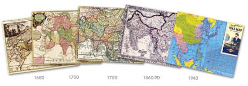
Below are several examples from the calendar.
1680
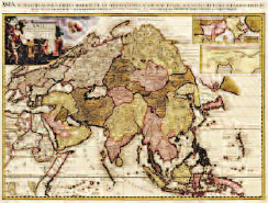 This map of Asia was drawn by the Dutch cartographer, Pieter van der Aa (1659-1733) around 1680. In the 1600s, coastlines were more accurate than interior lands on European maps and on this map, Tibet is in two parts and separate from China. You can see Lhasa in the brown shaded area to the right of the mythical lake from which Asia’s major rivers flow. Lhasa, spelled Lassa, is under the Kingdom of Barantola. On 17th and early 18th century maps, Tibet was sometimes referred to as Barantola or Kingdom of Barantola, probably meaning “country of Buddha” and may have Mongolian origins. You can also see “Thibet” to the northwest of the lake, also in a brown colored territory. The map may reflect some information found in Athanasius Kircher’s China Illustrata (1667), notably in its representation of Lhasa as not necessarily within Tibet itself, which lies to its west. At the time China Illustrata appeared, Tibet had not been incorporated into the Manchu Empire and was quite independent.
Source: Library of Congress, http://hdl.loc.gov/loc.gmd/g7400.ct001982
1700
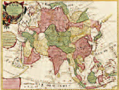 This 1700 map of Asia was drawn by the well-known French cartographer Guillaume de L’Isle (1675-1726). The description is in French and it shows the “Kingdom of Grand Tibet” (Roy. Du Grand Tibet), Lhasa (Lassa), the Tashi Lhunpo (Tache Linbou) monastery, Tsaparang (Chaparangue), the first Christian church built in 1626, and other places. Tibet is shown as including the “Kingdom of Ruthok” (Rudoc) and “Kingdom of Barantola,” terms which also appeared on the German cartographer Athanasius Kircher’s 1667 map. It was also thought to be bisected by a river that emptied into Lake Kokonor, which here is labeled Black Sea (Mer Noire). Parts of the Tibetan province of Amdo (known in Chinese as Qinghai) are shown as the southwestern tip of “Tartarie Chinois.” Tartary was a term used to designate land inhabited and ruled by Turkic and Mongol peoples of the Turkic and Mongol Empires. Guillaume de L’Isle lived in Paris and was one of the most influential cartographers of the first quarter of the 18th century. The map was published in 1700 in Paris.
Source: Library of Congress, http://hdl.loc.gov/loc.gmd/g7400.ct001980
1785
 This map, published in 1785, is by well known English cartographer William Guthrie (1708-1770) titled “An Accurate Map of Asia, According to the best Authorities.” While it shows Amdo and Kham as part of Tibet, much of western Tibet, that makes up today’s “Tibet Autonomous Region,” is shown as being part of Independent Tartary or Bukaria. As in previous maps in the calendar, Mongolia and Manchuria are also shown as being part of Chinese Tartary. The country of India encompasses Southeast Asia, and the Russian Empire has emerged. Reflecting the nature of the Qing state as a Manchu empire of several dominions, the map shows clear boundaries between China, “Chinese Tartary” (including Manchuria and Mongolia) and Tibet.
Source: Library of Congress, Call number G114.G9 1785
1860
 This 1860 map published by Samuel Augustus Mitchell, Jr. (1792-1868) shows Tibet as encompassing the entire Tibetan plateau, including “Little Tibet” which is now in Ladakh, India. Lake Yamdrok Tso, to the southwest of Lhasa, is shown here as a circular lake, as it is on all maps prior to 1880. And, Kanchenjunga (Kunghinginga) is shown at “28,178 feet, the highest known mountain on the globe” (even though Mt. Everest was declared to be the highest mountain in the world in 1852). This map also shows Tibet sharing a common border with Burma. “Map of Hindoostan, Farther India, China, and Tibet” was published by Samuel Augustus Mitchell, Jr. in Philadelphia, Pennsylvania, USA.
Source: David Rumsey Map Collection: Cartography Associates, http://www.davidrumsey.com/maps2886.html
1942
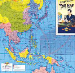 This 1942 map, issued five weeks after the U.S. entered the Second World War, is a fascinating slice of time, showing Allied and Axis controlled territories and bases. The green area of China shows territory controlled by the Nationalist Chinese under Chiang Kai Shek, whose government would soon flee to Taiwan. The light purplish area in northeastern China is under Japanese occupation. Tibet is shown here as independent, but does not include the northeastern province of Amdo. Much of Kham is shown as part of the short-lived province of Xikang. Printed by the map maker Rand McNally for oil company Sunoco, it features Lowell Thomas, the famous radio broadcaster. He and his son, Lowell Thomas, Jr., would travel to Tibet at the rare invitation of the Dalai Lama in 1949 when the Tibetan government was trying to gain international attention, support and legitimacy.
Source: David Rumsey Map Collection: Cartography Associates, http://www.davidrumsey.com/maps920006-23822.html
Related
- View a map of recent Tibetan self-immolations
- View a satellite image of Tibet
- View a map of sites of Tibetan demonstrations and protests
- ICT’s Store: Maps & Guides
- Resources (bibliography)
Sites compiled from various sources where protests are reported to have taken place since March 10, 2008.