
The people of Derge, a town in eastern Tibet, have risen up in opposition to the planned Kamtok (Ch: Gangtuo) hydropower project in their region. China’s move to build the dam despite local opposition is indicative of the Chinese government’s willingness to disregard negative impacts on Tibetan communities upstream in order to provide energy to the Chinese towns downstream.
This report expands on the Derge (Dege) situation and delves further into some of the systemic dangers of China’s dam-building spree on the Drichu (Jinsha) [1] river. We hope to elucidate the stark contrast between the Tibetan people’s deep-rooted connection to their ancestral lands and cultural heritage in Derge and beyond, and China’s authoritarian approach that views the displacement of Tibetans and the erasure of their civilization as an acceptable cost for serving the interests of the Chinese state.
Much has already been reported regarding the feared submergence of Wontö monastery and the displacement of upwards of 10,000 Tibetans due to the planned Kamtok Dam.[2] These fears reflect the familiar pattern of dislocation throughout Tibet, as recently reported by Human Rights Watch.[3]
Since 2016, the Chinese government has intensified its efforts to forcibly relocate Tibetan populations under the guise of policy initiatives euphemistically labeled as “extremely high-altitude ecological relocation” and “targeted poverty alleviation.” These programs are thinly veiled pretexts for the coercive displacement of Tibetans, facilitating the exploitation of Tibet’s abundant natural resources. The implementation of these policies has resulted in the involuntary resettlement of hundreds of thousands of Tibetans from their communities, paving the way for the unimpeded extraction and utilization of Tibet’s rich natural endowment, including minerals and water resources.
The Historical and Cultural Significance of Derge
In recognition of Tibetan culture, the Derge Printing House (known in Tibetan as Derge Parkhang), founded in 1729 and housing 325,520 printing plates containing significant Tibetan Buddhist classics, was inscribed on UNESCO’s Asia-Pacific Regional Register of Memory of the World on May 8, 2024.[4] China’s state media claimed the National Archives Administration had proposed the nomination of this printing house. It is worth emphasizing that the printing house continues to use old techniques without the use of electricity. China’s official state media Xinhua portrayed this inscription as a source of national pride for China, in line with its current policy of sinicizing Tibet and Tibetan culture as belonging to China.[5]
Yet despite China supporting UNESCO’s recognition of Tibetan treasure, smuggled video footage of Tibetans emerged in early February this year of Tibetans in Derge pleading the government against their pending displacement and loss of several monasteries of religious, cultural and historical significance.[6] In the past, at least one of the monasteries at risk had been recognized as a site of cultural significance by the government of China.
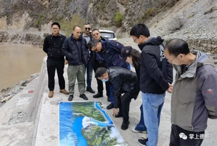
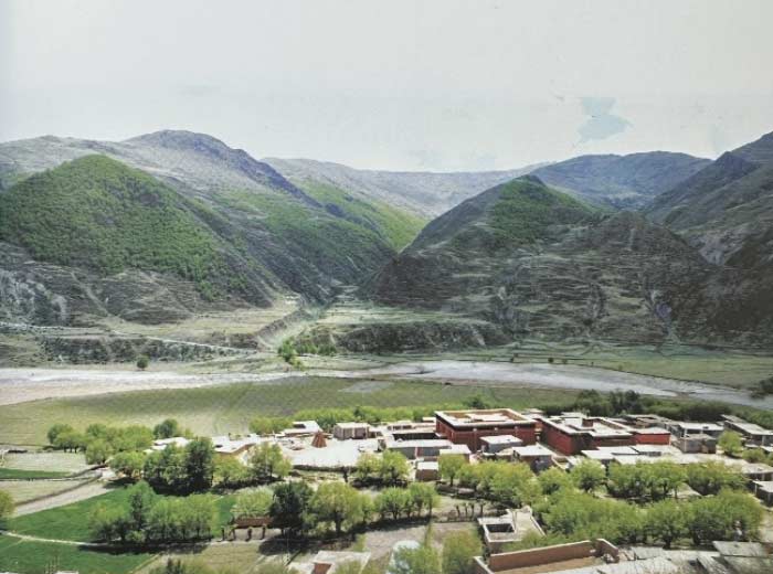
A survey team led by Chi Kang, a member of the Derge County Party Committee, conducting field work at Changra (Gonya) Town, the proposed location for the Kamtok Dam, on April 25, 2024.
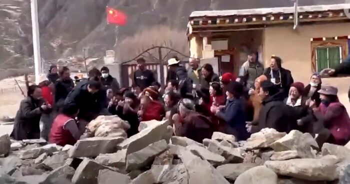
Tibetan villagers at Yena Monastery in Dege County pleading with visiting local Chinese officials on Feb. 20, 2024, against relocation to make way for the controversial Kamtok Hydropower project on the Drichu River. (Source: Radio Free Asia)
The historical and cultural area of Derge, known as the cultural hub of Kham, eastern Tibet, holds a special place in Tibetan history and cultural heritage. Derge was once a cradle of arts and culture, contributing significantly to the preservation and dissemination of Tibetan Buddhist teachings and literature.
Today, the historical kingdom of Derge is divided by Chinese-imposed administrative boundaries across provinces, prefectures, and counties. Derge straddles the Chamdo prefectural-level city in the Tibet Autonomous Region (TAR) and the Kardze Tibetan Autonomous Prefecture, which is under Sichuan Province.
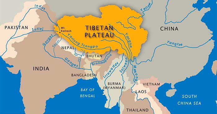
The Drichu is the watershed boundary between the officially designated Tibet Autonomous Region and Sichuan Province. With its headwater in the mountains of Tibet, the Drichu travels through Tibetan territory and onwards for over 3,900 miles, making it the longest river in Asia and the third-longest river in the world, through ten provinces of China before plunging into the East China Sea near Shanghai.
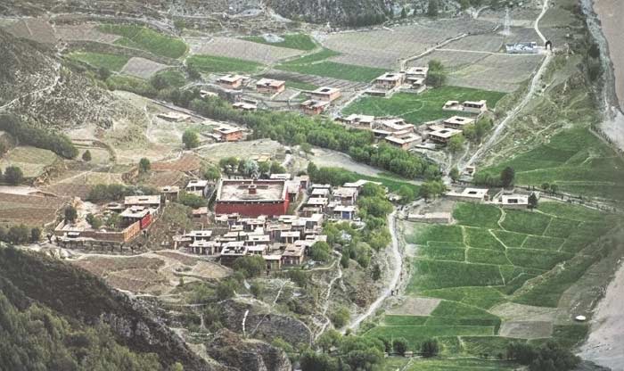
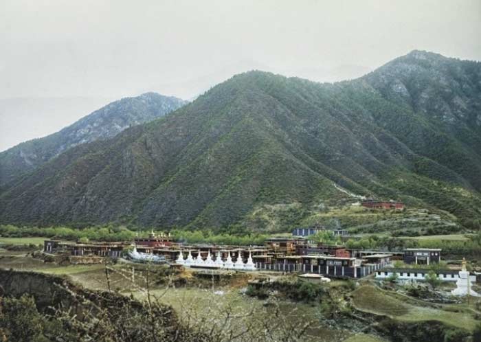
Tibetans in Derge have a close relationship with the Drichu, with villages and monasteries built near the river over centuries. In addition to the Derge Printing House, other structures of religious and historical significance include Wontö, Yena, and Khardo monasteries on the west bank of the river (falling under the administration of Derge County in Sichuan province), and Rabten, Tashi, and Gonsar monasteries on the east bank of the river (falling under the administration of Jomda county in the Tibet Autonomous Region). These monasteries came into focus early this year after Chinese authorities sent relocation orders to nearby villages to make way for the construction of a planned dam downstream at Kamtok, whose reservoir puts the villages and historical sites at risk of submergence.
In total there are 57 monasteries in Derge County, according to a 1995 official Chinese internal document.[7] A 2011 public publication on “Temple Records of Dege County” lists the monasteries according to the sects as consisting of 18 Sakya monasteries, 14 Nyingma monasteries, 11 Kagyu monasteries, 10 Bon monasteries, and 4 Gelug monasteries.[8]
Most of the monasteries in Derge County are centuries old. The monasteries at risk of submergence due to the planned Kamtok dam are ancient, with their oral history dating back to the 7th century and the artworks inside the monasteries going back to at least the 14th century.
A large number of artifacts of religious and cultural significance are at risk of submergence. These include ancient Buddhist scriptures, thangka paintings, and other relics that hold immense cultural and spiritual value for the Tibetan people (The artifacts inside Wontö, Yena, and Khardo monasteries are documented in Appendix 1).
Wontö Monastery
Full name: Wontö Rabten Lhunpo Tse Monastery
According to oral history, the origin of Wontö Monastery is attributed to a nephew of a descendant of the 7th century Tibetan king Tridhe Songtsen.
The toponym “Wontö” is derived from two distinct Tibetan terms. The first component, “Wonpo,” translates to “nephew” and the second component “tö” translates as “upper region” and is a popular reference to western Tibet. As the legend goes, during his return journey from eastern Tibet, when he was asked by a local person who he was and to where was he proceeding, he responded that he was a nephew (Tibetan: Wonpo) of the Choegyal (a reference to the Tibetan King) and was heading towards the “upper region” (Tö).[9]
The more than one-thousand-year-old monastery is originally said to have been of Bon religion but was converted to the Sakya tradition of Tibetan Buddhism after Drogon Choegyal Phagpa (13th century head of the Sakya tradition who also assumed political power in Tibet) arrived at the monastery upon his return journey from China.
The Wontö Monastery stands as a remarkable testament to the resilience of Tibetan culture, having withstood the ravages of time and turmoil. Despite events such as the invasion of a rival ruler in the mid-19th century and the infamous Cultural Revolution during the Mao era, the monastery has managed to safeguard its priceless cultural artifacts.
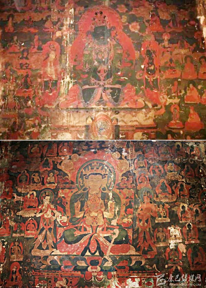
14th century murals in Wontö Monastery offering a glimpse into the rich artistic traditions of Tibet.
One of the monastery’s crowning glories lies in its exquisite murals, which have miraculously survived intact since the 14th century. These splendid works of art of the revered Lamdre lineage lamas, the Buddha, green Tara and many more adorn the walls as a testament to Tibetan history and deep-rooted Buddhist traditions.
Yena Monastery
Full name: Yena Tashi Lhatse Thekchog Choekyi Gatsel Shedrub Dhargayling
Yena Monastery is, according to oral history, blessed by Drogon Choegyal Phagpa, under whose influence it converted to the Sakya tradition from Drukpa Kagyu tradition of Tibetan Buddhism. This monastery was originally said to have been established by followers of Bon religion.
The monastery holds a rich cultural heritage and is steeped in legends and folklore. It was once home to 700 monks, which testifies to its importance and influence in the region.
The monastery was destroyed in 1967 at the beginning of the Cultural Revolution. After the Cultural Revolution, when the government of China adopted a relatively relaxed policy on religion, the devotees made efforts to preserve and revive the monastery.[10] In 1983, initiatives were taken to rebuild three temples and 45 monastic rooms, allowing the monastery to house around 80 monks again.[11]
Khardo Monastery
Full name: Thubten Phuntsok Shedrub Dargyeling Khardo Monastery
Founded by Lotsawa Pagor Vairocana (8th century scholar and eminent translator), Khardo Monastery has a rich historical legacy spanning several centuries. Pursuant to the decree issued by Drogon Choegyal Phagpa, Khardo Monastery has been bestowed with the distinguished status and privileged standing as the second-highest monastic institution within the Sakya tradition, ranking immediately after the Sakya Monastery located in central Tibet. In the 8th Rabjung[12] (corresponds to 15th century), the monastery received a consecration of immense significance when Thangtong Gyalpo, a revered Tibetan sage and historical figure, performed the sacred rituals. Thangtong Gyalpo’s involvement in the monastery’s consecration further solidified its spiritual and cultural importance within the region.
Khardo Monastery suffered destruction and desecration during the Cultural Revolution (1966-1976). Prior to the Cultural Revolution, there was no record of destruction.
In 1983, as China’s policies towards religion became relatively more relaxed, efforts were made by devotees to revive and reconstruct Khardo Monastery. This initiative aimed to restore the monastery’s physical structures and reinvigorate its spiritual practices, allowing the continuation of its centuries-old traditions.
Rivers in Tibet (Image courtesy of Michael Buckley, author of Meltdown in Tibet)
From Drichu to Yangtze: The River Powering China
Drichu from the mountains of Tibet flows downstream into China where it is known as Yangtze (Changjiang). The Yangtze River holds immense significance for China serving as an economic driver throughout China’s history. The Yangtze basin (2000 miles from west to east and over 600 miles from north to south with one-third of China’s population living in it[13]) feeds China’s great granary, producing a significant portion of the country’s agricultural output and is an engine for rapid economic growth accounting for around 30% of China’s GDP.[14] The river connects China’s interior to the coast facilitating trade and movement of people along the industrial belts and high-tech development zones.
Modern China’s thinkers and leaders had been envisioning harnessing the power of the river for China’s thrust into economic development and modernity. The father of modern China, Sun Yat-sen, envisioned massive hydropower projects on the Yangtze to electrify central China, catapulting China into modernity. China has around 87,000 dams today according to the non-governmental organization International Rivers. The dams have been built to electrify China and redirect the flow of rivers, especially to northern China, for irrigation and to control flooding.[15]
Aside from envisioning rivers as a tool to catapult China into modernity, China’s thinkers and leaders have fallen short of estimating a variety of costs that come with dams. Today, the Yangtze faces several environmental challenges that threaten its ecosystem and the communities that depend on it. These include pollution from industrial and agricultural sources, siltation, loss of biodiversity, shrinking wetlands and flooding.
Climate change has serious implications for these rivers. In the context of Tibet’s riparian systems, the climate crisis stands to impact rivers in multiple ways, especially the uncertainty of water volume in rivers. Predictions suggest that water flows will become uncertain with anomalous torrential downpours and accelerated snow melt. This uncertainty will almost certainly produce contrasting extreme effects of drought or flooding with the potential to exacerbate the frequency and severity of landslides. This is because changing precipitation patterns, rising temperatures, and glacial melt can all affect the stability of slopes and trigger landslides.
Specifically, flooding along the Yangtze is a major concern. The rainy season in China is May through August, with the areas to the south of the river experiencing downpours in May and June while the areas to the north of the river experience a rainy season in July and August. Just as the river supports Chinese lives, it also takes scores owing to floods affecting the dense population along the river. Previous Yangtze flood-based deaths range from 3,004 in 1998[16] to 145,000 in 1931.[17]
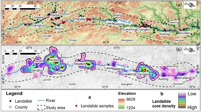
Map of active landslides in the upper Drichu region” by Shengsen Zhou et al., Remote Sensing 16(1), p.100 Figure 3a, (2024), CC BY 4.0, https://creativecommons.org/licenses/by/4.0/. Used under a CC BY 4.0 license.
Landslide Hotspot
Changes in precipitation patterns, climate change, glacial lake outburst floods and landslides in the high-altitude Tibetan areas along the Drichu are all factors relevant to flooding in China.
Along the Drichu, several historical landslide-flood events have occurred, causing significant damage. More recently, in October 2018, a massive landslide occurred in Po (Bolo) Township in Jomda county on the west bank of the river. The landslide formed a barrier lake, rapidly raising water levels to approximately 5,600 meters in length, 200 meters in width, and 70 meters in height.[18] This geological disaster prompted the local government to evacuate over 6,000 people, with more than 20,000 residents affected by the barrier lake. The situation escalated on November 3, 2018, when the initial landslide was reactivated at the same site, blocking a section of the river once again. The resulting barrier lake led to the relocation of 67,449 people in Tibetan areas in Sichuan and neighboring Yunnan province. Two days later, when the water was discharged through a man-made floodway, the ensuing flood devastated several townships, including Drichukha, Kardze, Po and others. The 900-year-old Po Monastery, a significant religious and historical site, was completely submerged, with its invaluable relics ruined beyond repair.
The Drichu landslide mass remains a persistent threat, with no guarantee that a similar catastrophic event will not occur again. This geological event showed the vulnerability of communities and infrastructure along the Yangtze River basin to disasters exacerbated by human activities and climate change.
Mudslide and flooding in the neighboring Nyakchukha (Yajiang) County on June 10, 2024, due to heavy rainfall.
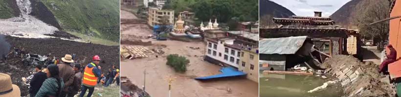
A landslide near Po (Bolo) Township, Jomda (Jiangda) County, blocked the Drichu River in October 2018, forming a barrier lake 5 km long that submerged two villages and the 900-year-old Po monastery. (Images via Tibet Nature Environmental Conservation Network)
The upper Drichu area is a hotspot of landslides, with most of the area landslides located between the Kamtok dam and the immediate downstream Yanbi dam.
Using remote sensing technologies, optical satellite remote images and UAV images, Chinese scientists in a December 2023 study of active landslides in upper Drichu region identify 246 active landslides of which 27 are specifically located in the Kamtok Reservoir area.[19]
In a detailed study of the reservoir area of ten dams (planned, under construction or operational) between Tashi Rangkhar (Benzilan) in Dechen (Deqin) county in Yunnan Province and Kamtok in Jomda county in the Tibet Autonomous Region, the researchers identify the presence of three zones of concentrated active landslide areas. Zone III, situated within the planned Kamtok dam and the immediate next downstream Yanbi dam, had 127 landslides or 61.4% of all the 207 landslides in the three zones of study between Kamtok in the TAR and Tashi Rangkhar in Yunnan.[20]
The researchers acknowledge that due to the high elevations and steep terrain, which make the entire area inaccessible to humans, traditional geological surveys using monitoring equipment have not been extensively carried out to study the landslides.[21]
While the Chinese scientists’ study identified active landslides in the upper Drichu region, it is important to recognize the limitations of this research and the pressing need for further investigations. Landslides can have devastating consequences, causing loss of life, property damage, and environmental degradation.
Merely identifying the occurrence of landslides is not enough; it is imperative to uncover the root causes that trigger these geological events. Factors such as soil composition, tectonic activity, deforestation, and activities like hydropower dam construction and mining can all contribute to the destabilization of slopes and the subsequent occurrence of landslides. Serious studies seem lacking to identify the causal factors for the landslides, their correlation with climate change, or measures to mitigate further landslides or damage due to them. It is crucial to complete comprehensive, inclusive environmental impact assessments to ascertain the causal factors, climate change correlations, and mitigation measures necessary to safeguarding communities and protecting the environment.
Investigating the correlation between climate change and landslide occurrences in the upper Drichu region is vital for developing long-term adaptation strategies and mitigating the potential consequences of a changing climate. Building dams is not a solution to combating landslides to protect dam infrastructures.
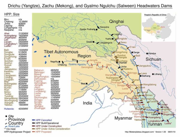
A 2013 map showing cascade of dams in Tibet. Suwalong on Drichu River became operational in August 2022. Yebatan is likely to begin operating around late 2025. (image courtesy of Michael Buckley, author of Meltdown in Tibet)
Chinese Study on Flood Routing and High Dam Interception
In a 2020 study titled “Flood Routing Process and High Dam Interception of Natural Discharge,” Chinese scientists argue that high dams are effective in reducing the inundation area of downstream farmlands and extending the evacuation time for downstream Chinese residents during floods.
Yebatan Dam and Flood Risk Elimination
Studying the Yebatan dam, the third dam downstream of the Kamtok dam and the seventh in a series of 13 dams, the Chinese researchers make a bold claim based on simulation results. They assert that the “Yebatan Hydropower Station can eliminate the outburst flood risk even under the most dangerous situations.”
The researchers argue that the Yebatan dam can “reduce the flood peak and delay the peak flood arrival time.” Specifically, they state that “the flood peak decreased more obviously when it was closer to the upstream area, and the flood peak arrival time was more delayed when the flood spread further downstream.” Additionally, they claim that “the downstream water depth was reduced by approximately 10 meters, and the inundation area was reduced to half of the natural discharge.”[22]
However, the study fails to consider the future trajectory of worsening of floods in the future due to climate change. Simulation models may not be entirely accurate for taking the current situation into account while omitting probable gigantic future floods due to the effects of climate change.
The Chinese researchers are singularly focused on the strength and capacity of the dam on Tibetan territory. However, they do not address the potential destruction of life and culture of the Tibetans at risk living in the area or further upstream of the Drichu River. The study makes no effort to identify causal factors or recommend measures to reduce floods in the future, which is the root problem.
This concern about the uncertainty of river flow is supported by another study conducted by another group of Chinese researchers studying the runoff in the upper reaches of Drichu River.[23] The researchers acknowledge that “the runoff variation in the upper Jinsha River is a complex phenomenon under the influence of multiple factors, and that influence of factors on runoff varies significantly in different months and spatial distribution.”
The researchers identify the key factors affecting the runoff dynamics due to a combination of the preceding month’s runoff, snowmelt and precipitation throughout the year as follows:[24]
November to March: Dominance of Preceding Month’s Runoff
During the period from November to March, the primary factor influencing the runoff in the upper Drichu River is the runoff from the preceding month. This factor’s contribution can reach more than 85%, while the influence of rainfall and snow is relatively weak during this period.
April-May: Snowmelt Period
April and May mark the snowmelt period for the upper Drichu basin. During this time, the influence of snow on runoff increases significantly. In May, the contribution of snow can reach more than 65%, and the impact of snow on runoff exhibits a time lag effect of approximately one month. It is noteworthy that the snow affecting the runoff is primarily distributed in the area spanning from the Kamtok station to the Batang station.
June: Complex Interplay of Factors
In June, the factors influencing runoff become more complex. Early runoff, precipitation, and snow all have a significant impact on the runoff, with their contributions being roughly equal.
July to September: Rainfall Dominance
From July to September, rainfall plays a major role in the runoff changes. The contribution of rainfall in each month exceeds 50%, with the contribution of August rainfall reaching more than 80%. The runoff in July and August is primarily influenced by the rainfall in the same month, whereas September’s runoff is mainly influenced by the rainfall from the preceding month.
October: Influence of Preceding Month’s Runoff and Rainfall
The runoff in October is primarily influenced by the runoff and rainfall from the preceding month. The combined contribution of these two factors can reach more than 70%.
This comprehensive understanding of the seasonal variations and the dominant factors influencing runoff in the upper Jinsha basin is crucial for effective water resource management, flood control, and environmental conservation efforts in the region.
They also caution that “long-term runoff forecast has been facing the problems of low accuracy and reliability, especially as global climate change has changed the precipitation and snow melt process in the cold region of western China, which has caused far-reaching effects on the runoff mechanism process in the basin, further increasing the uncertainty of long-term runoff forecast in Jinsha River.”[25]
China’s water resources management regulations require hydropower companies to submit annual power generation and water allocation plans to the government and recommend consideration of long-term runoff forecasts in plans. But in practice, companies often discard the long-term runoff forecast and make their plan on multi-year average runoff conditions.[26]
This video is circulating on Wechat & Weibo, melting permafrost, flowing like lava in #Tibet. pic.twitter.com/lKISKIbvAZ
— tshakya ཚེ་རིང་ཤཱཀྱ། (@Lhatseri) September 8, 2017
Permafrost flow in Yulshul (Yushu) in 2010 via @Lhatseri
Climate Change and Tibetan Vulnerability
It is important to study the long-term runoff as global climate change has changed the precipitation and snowmelt process in Tibet.
Another group of Chinese researchers studying water storage in the upper Drichu region identify that the water storage in the region has two peaks within a year with the highest peak in August or September and the lowest between March and May.[27] They also note in their study dataset from 2003 to 2012 that the runoff peak occurs earlier than storage each year due to the steep topography in the upper Drichu region.[28] However, anomalies do occur as happened in 2006 between the 2003 and 2012 study period. Although precipitation has played the main role in runoff variations in the past decades, the researchers acknowledge that other research scientists attribute supra permafrost melt as the dominant factor for the runoff from June 2016 to May 2018.[29] Some other Chinese researchers like Gao et al. and Li et al. have found that the upper Drichu region has experienced permafrost degradations due to global warming for the past few decades. Thus the runoff in the upper Drichu region is not only due to the precipitation but also due to permafrost and glacier melt. A 2015 study of permafrost melt jointly led by Yingkyui Li of the University of Tennessee and the Chinese Academy of Sciences also identified permafrost melt as the central driver of environmental hazards potentially causing flooding due to the expansion of high-altitude lakes.[30]
Conclusion
Tibetans have played no role in carbon-intensive industries throughout history, neither on the demand side nor on the supply side, yet the threat of flooding due to climate change phenomena in Tibet makes the victims of climate change even more vulnerable.
The Chinese government’s singular focus on protecting the Chinese people and the economy downstream, while disregarding the potential impact on Tibetan communities upstream, raises concerns about environmental justice and the burdens borne by the Tibetan community by continued dam building.
Appendix 1: Relics and sacred objects inside Wontö, Yena and Khardo Monasteries »
Footnotes:
[1] The Drichu River originates in the mountains of Tibet and flows through China. The Chinese call the Drichu ‘Jinsha,’ and it becomes Changjiang or Yangtze when it travels through the Chinese heartland before ending in the East China Sea.
[2] International Campaign for Tibet, “Derge Protests Put Dams Back on the Agenda, Highlight Tibet’s Role in Powering China,” International Campaign for Tibet, April 30, 2024, https://savetibet.org/derge-protests-put-dams-back-on-the-agenda/. See also “China Cracks Down on Tibetan Protest Against a Hydropower Project in Dege,” March 12, 2024, https://thediplomat.com/2024/03/china-cracks-down-on-tibetan-protest-against-a-hydropower-project-in-dege/.
[3] “‘Educate the Masses to Change Their Minds’ China’s Forced Relocation of Rural Tibetans” (Human Rights Watch, May 21, 2024), https://www.hrw.org/report/2024/05/22/educate-masses-change-their-minds/chinas-forced-relocation-rural-tibetans.
[4] “སྡེ་དགེའི་པར་ཁང་འཛམ་གླིང་དྲན་ཤེས་མིང་ཐོར་ཚུད།德格印经院入选《世界记忆亚太地区名录》,” Weixin Official Accounts Platform, May 8, 2024, https://mp.weixin.qq.com/s/Y3zMClmyVoL_PLbwLCcp8g. See also “20 New Inscriptions on the MOWCAP Regional Register – Memory of the World Committee for Asia and the Pacific,” May 2024, https://www.mowcapunesco.org/core-activities/mowcap-regional-register-2024/. Derge Printing House is not at risk of submergence due to the planned Kamtok dam, but many other Tibetan culture sites are at risk.
[5] Xinhua, “3 More Chinese Items Inscribed on UNESCO Memory of the World Regional Register-Xinhua,” May 9, 2024, https://english.news.cn/20240509/9892f0818cba40359909436097e78bf5/c.html.
[6] Cindy Carter, “More Than 100 Arrested Following Dam Protest in Tibetan Region of Sichuan Province,” China Digital Times (CDT), February 24, 2024, https://chinadigitaltimes.net/2024/02/more-than-100-arrested-following-dam-protest-in-tibetan-region-of-sichuan-province/.
[7] ཁམས་ཕྱོགས་དཀར་མཛེས་ཁུལ་གྱི་དགོན་སྡེ་སོ་སོའི་ལོ་རྒྱུས་གསལ་བར་བཤད་པ་ནང་བསྟན་གསལ་བའི་མེ་ལོང་ཞེས་བྱ་བ་བཞུགས། < The Clear Mirror of Buddhism, a clear explanation of the history of the individual monasteries in the region of Karze in Kham> དེབ་དང་པོ། ཀྲུང་གོའི་བོད་ཀྱི་ཤེས་རིག་ཞིབ་འཇུག་ལྟེ་གནས་ཀྱི་ཆོས་ལུགས་ལོ་རྒྱུས་ཞིབ་འཇུག་སོའོ་དང་། ཀྲུང་གོ་བོད་བརྒྱུད་ནང་བསྟན་མཐོ་རིམ་སློབ་གླིང་བོད་བརྒྱུད་ནང་བསྟན་ཞིབ་འཇུག་ཁང་། ཟི་ཁྲོན་ཞིང་ཆེན་དཀར་མཛེས་ཁུལ་ཆོས་ལུགས་ཅུད། དཀར་མཛེས་ཁུལ་ཡིག་བསྒྱུར་ཅུད་བཅས་ལས་ཁུངས་བཞི་ནས་བརྩམས་སྒྲིག་བྱས། (ནང་ཁུལ་ཡིག་ཆ་ཡིན་པས་། ཉར་ཚགས་བྱེད་རྒྱུར་ཡིད་གཟབ་བྱེད་དགོས།) 1995 ལོའི་ཟླ་༡༠ཚེས་25ལ།
[8] སྡེ་དགེ་རྫོང་དགོན་པའི་ལོ་རྒྱུས། Temple Records of Dege County སྡེ་དགེ་རྫོང་དགོན་པའི་ལོ་རྒྱུས་རྩོམ་སྒྲིག་ཡུ་ཡོན་ལྷན་ཚོགས། སྲིད་གྲོས་སྡེ་དགེ་རྫོང་ཨུ་ཡོན་ལྷན་ཁང་། མི་རིགས་དཔེ་སྐུན་ཁང་། 2011
[9] སྡེ་དགེ་རྫོང་དགོན་པའི་ལོ་རྒྱུས། Temple Records of Dege County སྡེ་དགེ་རྫོང་དགོན་པའི་ལོ་རྒྱུས་རྩོམ་སྒྲིག་ཡུ་ཡོན་ལྷན་ཚོགས། སྲིད་གྲོས་སྡེ་དགེ་རྫོང་ཨུ་ཡོན་ལྷན་ཁང་། མི་རིགས་དཔེ་སྐུན་ཁང་། 2011 , 75.
[10] The Chinese party-state’s policy on religion was relaxed during the early 1980s compared to the policies under Mao Zedong past leadership and Xi Jinping’s current leadership.
[11] ཁམས་ཕྱོགས་དཀར་མཛེས་ཁུལ་གྱི་དགོན་སྡེ་སོ་སོའི་ལོ་རྒྱུས་གསལ་བར་བཤད་པ་ནང་བསྟན་གསལ་བའི་མེ་ལོང་ཞེས་བྱ་བ་བཞུགས། དེབ་དང་པོ། ཀྲུང་གོའི་བོད་ཀྱི་ཤེས་རིག་ཞིབ་འཇུག་ལྟེ་གནས་ཀྱི་ཆོས་ལུགས་ལོ་རྒྱུས་ཞིབ་འཇུག་སོའོ་དང་། ཀྲུང་གོ་བོད་བརྒྱུད་ནང་བསྟན་མཐོ་རིམ་སློབ་གླིང་བོད་བརྒྱུད་ནང་བསྟན་ཞིབ་འཇུག་ཁང་། ཟི་ཁྲོན་ཞིང་ཆེན་དཀར་མཛེས་ཁུལ་ཆོས་ལུགས་ཅུད། དཀར་མཛེས་ཁུལ་ཡིག་བསྒྱུར་ཅུད་བཅས་ལས་ཁུངས་བཞི་ནས་བརྩམས་སྒྲིག་བྱས། (ནང་ཁུལ་ཡིག་ཆ་ཡིན་པས་། ཉར་ཚགས་བྱེད་རྒྱུར་ཡིད་གཟབ་བྱེད་དགོས།) 1995 ལོའི་ཟླ་༡༠ཚེས་25ལ།, 460.
[12] Rabjung in the Tibetan calendar is a sexagenary cycle, unlike the Gregorian centennial cycle.
[13] “Yangtze River,” A Visual Sourcebook of Chinese Civilization, https://depts.washington.edu/chinaciv/geo/yangtze.htm. See also “China’s Chang Jiang: Dealing with the Deluge,” Association for Asian Studies, https://www.asianstudies.org/publications/eaa/archives/chinas-chang-jiang-dealing-with-the-deluge/.
[14] Wei Qi et al., “Economic Growth Dominates Rising Potential Flood Risk in the Yangtze River and Benefits of Raising Dikes from 1991 to 2015,” Environmental Research Letters 17, no. 3 (March 1, 2022): 034046, https://doi.org/10.1088/1748-9326/ac5561.
[15] “China,” International Rivers, https://archive.internationalrivers.org/programs/china.
[16] “Final Report on 1998 Floods in the People’s Republic of China” (OCHA, September 29, 1998), https://reliefweb.int/report/china/final-report-1998-floods-peoples-republic-china.
[17] Yangtze River, New World Encyclopedia, https://www.newworldencyclopedia.org/entry/Yangtze_River.
[18] Guilan Liang et al., “Two Huge Landslides That Took Place in Quick Succession within a Month at the Same Location of Jinsha River,” Landslides 16, no. 5 (May 2019): 1059–62, https://doi.org/10.1007/s10346-019-01165-z.
[19] Shengsen Zhou et al., “Analysis of the Spatial Distribution and Deformation Types of Active Landslides in the Upper Jinsha River, China, Using Integrated Remote Sensing Technologies,” Remote Sensing 16, no. 1 (December 26, 2023): 100, https://doi.org/10.3390/rs16010100., 13.
[21] The hydropower stations currently planned or under construction for the “one reservoir and thirteen stages” layout for the upper Drichu river from upstream to downstream are Shirong (Xirong), Sela (Saila), Kangthung (Guotong), Kamtok (Gangtuo), Udpel (Yanbi), Polu (Bolo), Yepathan (Yebatan), Lhak (Lawa), Bathang (Batang), Sowanang (Suwalong), Trangbo (Changbo), Shollung (Xulong) and Tashi Rangkhar (Benzilan).
[22] Bin-Rui Gan et al., “Flood Routing Process and High Dam Interception of Natural Discharge from the 2018 Baige Landslide-Dammed Lake,” Water 12, no. 2 (February 23, 2020): 605, https://doi.org/10.3390/w12020605., 1.
[23] Le Wang et al., “Attribution Analysis of Runoff in the Upper Reaches of Jinsha River, China,” Water 14, no. 17 (September 5, 2022): 2768, https://doi.org/10.3390/w14172768.
[27] Haochun Du et al., “Characterization of the Recharge-Storage-Runoff Process of the Yangtze River Source Region under Climate Change,” Water 12, no. 7 (July 8, 2020): 1940, https://doi.org/10.3390/w12071940., 12.
[30] Brittany Watts, “On Tibetan Plateau, Permafrost Melt Worse Than Glacial Melt” GlacierHub, January 14, 2015, https://glacierhub.org/2015/01/14/permafrost-melt-poses-a-greater-threat-than-glacial-melt-in-the-tibetan-plateau/.